Helicopter with hexagonal screen maps fresh and salt groundwater
The information collected is crucial for sustainable groundwater management, protection of drinking water sources, limiting salinization.
Published on August 13, 2025
© FRESHEM

Team IO+ selects and features the most important news stories on innovation and technology, carefully curated by our editors.
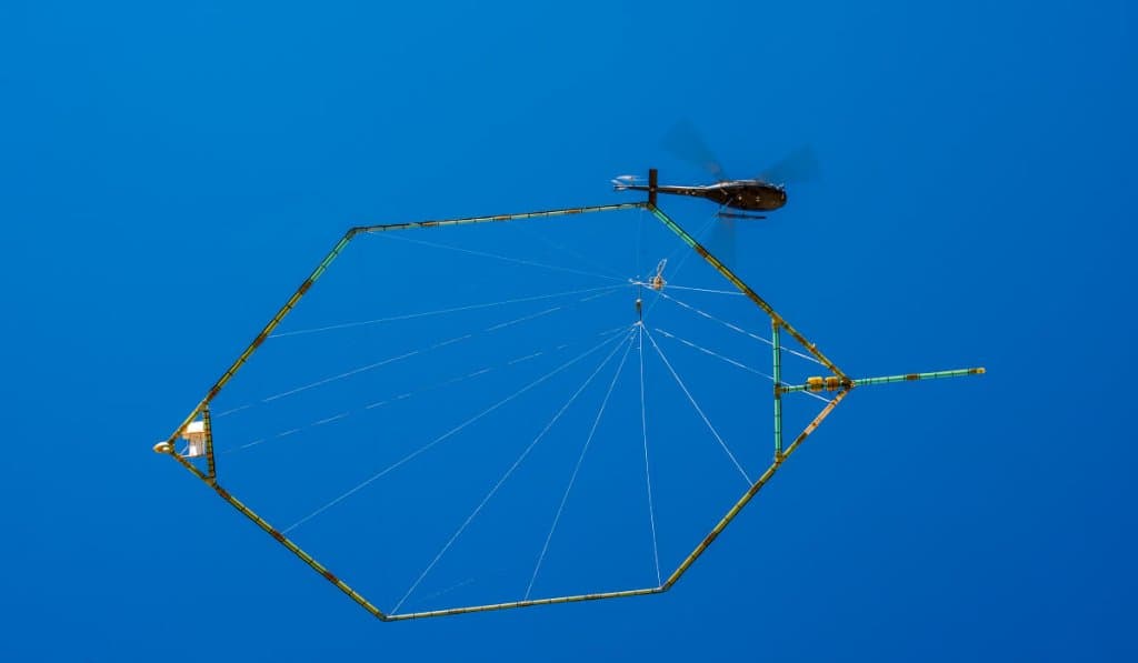
Over the coming months, a helicopter equipped with a large hexagonal screen will be seen conducting soil surveys at various locations in the Netherlands. This innovative project will map the subsurface to a depth of 200 meters. The research will continue until the end of 2025.
The research is part of the FRESHEM-NL project. This is a collaboration between seven provinces, seven water boards, five drinking water companies, and the research institutes Deltares and TNO - Geological Survey of the Netherlands. The aim is to gain insight into the location of clay layers and the distribution of fresh, brackish, and salt groundwater. This information is crucial for sustainable groundwater management, protection of drinking water sources, and limiting salinization.
Fresh, salt, and brackish
Both brackish and salt groundwater occur in coastal areas, while deeper freshwater is essential for drinking water supplies. Sea level rise, climate change, and increasing water use are putting pressure on these freshwater resources and increasing salinization, which has negative consequences for nature, agriculture, and drinking water. FRESHEM-NL uses helicopter measurements to collect detailed data on the salt content and clay layers in the soil, creating a 3D map up to 200 meters deep. This information helps managers and users make sustainable choices for the use and conservation of groundwater.
Knowledge about the distribution of fresh and salt groundwater and the presence of clay layers in the subsurface is important for water managers, industries, drinking water companies, the agricultural sector, and nature organizations. They can use this information to make decisions about the sustainable management and use of groundwater resources. In addition, the results help to optimize existing and new monitoring plans and models. The results of FRESHEM-NL are made publicly available via an accessible viewer.
Electromagnetic signals
The helicopter flies at an altitude of approximately 80 meters. A large hoop-shaped sensor hangs about 35 meters below the helicopter. This instrument emits weak electromagnetic signals, similar to those of a mobile phone. These signals are used to create a 3D model of the subsurface. This model shows where fresh or salt groundwater is located and where clay layers are present. The measurements are safe for humans, animals, and nature.
To minimize disruption to humans and animals, flights are not conducted over built-up areas or directly above homes and businesses. The research is also conducted outside of the breeding season. Despite these precautions, temporary noise disturbance cannot be completely ruled out.